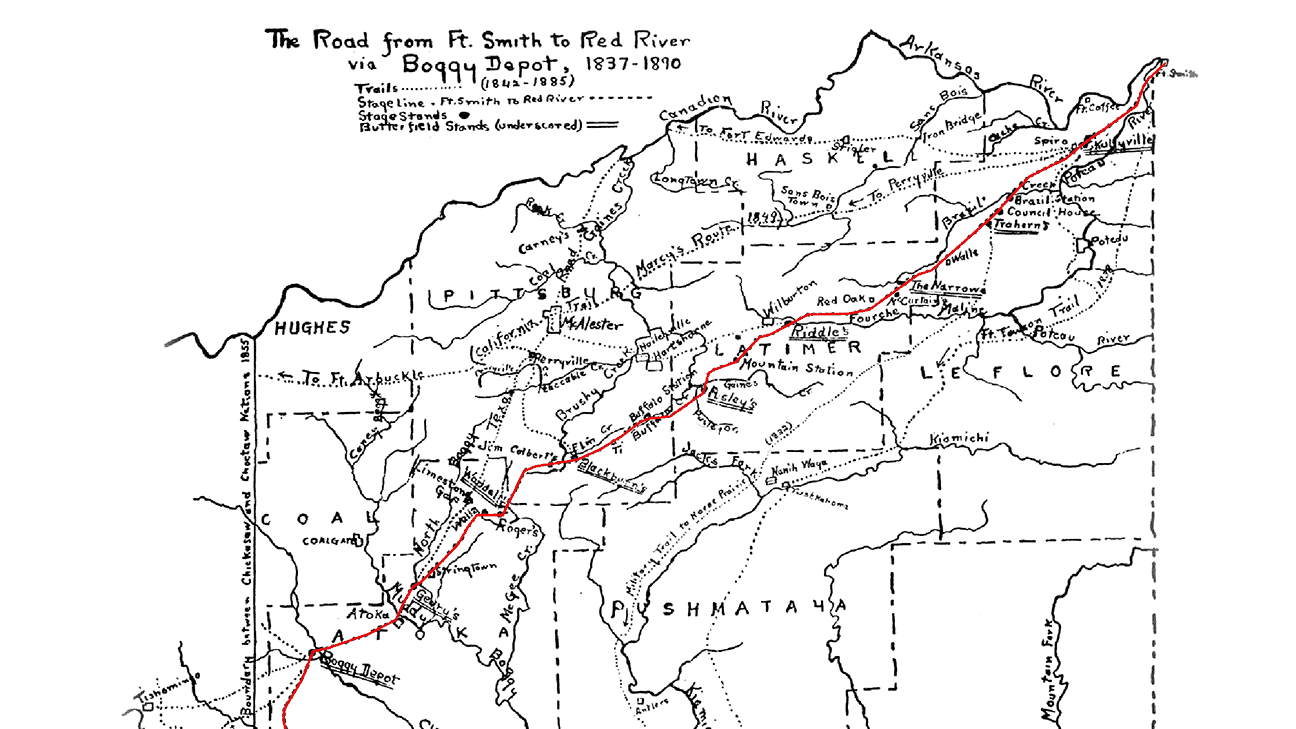
Map of the Butterfield Stage Line
The Butterfield Overland Mail Route through Choctaw Nation
Iti FabvssaPublished July 1, 2025The Butterfield Overland Mail Company’s Butterfield Stagecoach Line operated from 1858 to 1861, covering an immense distance of over 2,800 miles across a variety of terrains. The Butterfield Overland Mail Company provided vital transportation for both passengers and U.S. Mail from Memphis, Tennessee, and St. Louis, Missouri, to San Francisco, California – bridging the eastern United States with the rapidly expanding West. From Fort Smith, the stagecoach journeyed southwest across Choctaw Nation, passing through key stops in Skullyville and Old Boggy Depot before reaching Colbert’s Ferry on the Red River.
The Indian Territory segment alone stretched roughly 192 miles and utilized existing wagon trails that had been established during the Choctaw and Chickasaw Removals, as well as U.S. Army Movements, which took an estimated 38 hours to traverse (Everett 2010). Although its operation was brief, the overland mail route was an ambitious and complex undertaking and an extraordinary logistical achievement for its time.
The establishment of the Butterfield Trail led to increased traffic and new infrastructure throughout the Choctaw Nation. While no longer a continuous route, many traces, structures, landmarks, and markers related to the Butterfield Overland Mail Company in Choctaw Nation still remain (Dragoo 2024).
In 1858 and 1859, the General Council of the Choctaw Nation enacted legislation granting individuals the privilege and authority to construct and operate toll bridges, turnpikes, and toll gates along the route. Stations strategically placed about every 16 miles through Indian Territory offered essential services, including fresh teams of horses, hay, grain, and water for livestock, as well as food, drink, and occasionally lodging for passengers, which ensured efficient and reliable travel.
The Overland Mail Company issued contracts to keep the relay stations open at a rate of $125 to $175 per quarter. The station keepers in Indian Territory were predominantly Choctaw, Chickasaw, or Intermarried White.
Station owners also collected tolls from every non-citizen person, animal, and wagon wheel that passed through. This system not only supported the movement of people and goods but also generated revenue and encouraged local enterprise within the Nation.
Within Indian Territory, twelve official Butterfield stage stations were established, supplemented by informal stops where travelers might secure supplies or assistance. From Fort Smith, the stations were as follows: Walker’s Station, Trahern’s Station, Holloway’s Station, Riddle’s Station, Pusley’s Station, Blackburn’s Station, Waddell’s Station, Geary’s Station, Boggy Depot, Nail’s Crossing, Fisher’s Station, and Colbert’s Ferry.
Walker’s Station, located at Skullyville, near present-day Spiro, was in the old Choctaw Agency building, which had been used by the U.S. Indian Agent assigned to the Choctaw Nation. The Choctaw Agency served as a liaison between governments, similar to how the U.S. Consulate functions today. The Choctaw Agency at Skullyville was later taken over by Tandy Walker, then Governor of the Choctaw Nation.
In September 1858, Waterman Ormsby, the first through passenger on the Butterfield, reported that Governor Walker personally came out and helped hitch a fresh team of horses to the stage. Trahern’s Station, near present-day Latham, was situated near the Moshulatubbee District’s Council House, while Holloway’s Station at the Narrows was located in Red Oak, where meals were also served at Edwards Store five miles to the east.
The next stations included Riddle’s Station, near present-day Lutie; Pusley’s Station, near present-day Higgins; Blackburn’s Station; Waddell’s Station, near present-day Wesley; and Geary’s Station, near present-day Stringtown.
Approximately 10 miles west of present-day Atoka, the trail also ran through Boggy Depot, which was a key hub and served as the Choctaw Capital around this time. In 1858, Ormsby described Boggy Depot as “several painted houses and a store” and commented on recent violence nearby precipitated by the political crisis around the 1857 Skullyville Constitution.
In present-day Bryan County, stations included Nail’s (or Blue River) Crossing near Kenefic, where a bridge was under construction over the Blue River at the time of Ormsby’s visit, Fisher’s Station at Carriage Point near Durant, and Colbert’s Ferry on the Red River near present-day Colbert in the Chickasaw Nation.
At its peak, the Butterfield mail stages traveled this route twice each week, facilitating America’s westward expansion.
The outbreak of the Civil War in mid-1861 brought a sudden halt to mail service across Indian Territory, disrupting the vital communication lines established by the Butterfield Overland Mail. In March 1861, Congress voted to move the Overland Mail service, and the Butterfield shifted operations to northern routes less affected by the conflict. Although mail service resumed after the war, the landscape of American transportation was significantly altered.
The completion of the transcontinental railroad in 1869 marked the end of overland stage routes for long-distance mail delivery. While the Butterfield Trail ceased to function as a national thoroughfare, segments of it remained in use for years afterward.
The U.S. National Park Service (NPS) officially designated the Butterfield Overland Mail Route a National Historic Trail on Jan. 5, 2023. It is perhaps the longest National Historic Trail to date. Signage and interpretation will be developed and implemented as NPS trail planning proceeds. The Oklahoma Chapter of the Butterfield National Historic Trail Association (OK-BNHTA) is working with the National Park Service in this effort.
For more information on the Edwards Store, which still stands along the Butterfield trail in Latimer County, see The Edwards Store on Facebook. A comprehensive set of resources on the Indian Territory segment of the Butterfield is also available at susandragoo.com.
References Cited
- Dragoo, Susan (2024) Finding the Butterfield: A Journey Through Time in Indian Territory. Dragoo Adventures Media, Norman, Oklahoma.
- Everett, Dianna (2010) “Butterfield Overland Mail,” The Encyclopedia of Oklahoma History and Culture.
- Picture 388284964, Picture Map of the Butterfield Stage Line by Muriel H. Wright, Chronicles of Oklahoma Vol. 35 No.1 1957