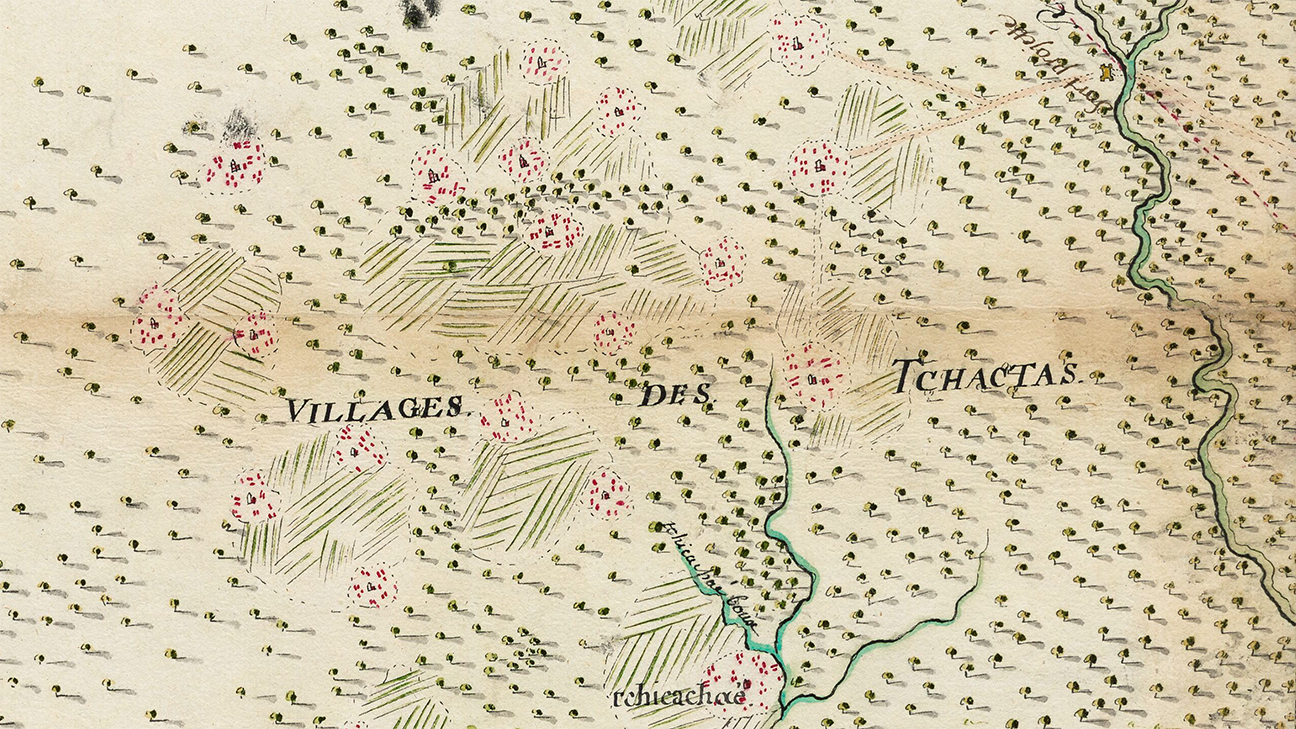
Figure 1. Close-up view of select Choctaw villages in Carte pour donner une idée de la position des villages sauvages...
Historical Map Research: Continuing collaborations with the Musée du Quai Branly – Jacques Chirac
Published March 1, 2026Last month, we discussed the research and exhibit collaborations between the Choctaw Nation Historic Preservation Department and the Musée du quai Branly-Jacques Chirac in Paris, France. Throughout this collaboration, we have analyzed historical French maps of the Choctaw homeland. Many of these maps were created in France using records by French explorers, who in turn, got their information from Choctaw people.
Many of the maps contain information that is useful when doing research, of the lifeways of our Choctaw ancestors. This month, we would like to highlight a couple of maps that we have analyzed and to share an exciting project that came from these collaborations.
The first map we want to discuss is an anonymous map created possibly between 1730 and 1735 titled Carte pour donner unée idee de la position des villages sauvages… which translates to: A map to give an idea of the location of the Indian villages. It is housed at the Defense Historical Service located in Vincennes, France. This early map was created to show the locations of Native villages in the area of early French settlements in what is known as French Lower Louisiana. Figure 1 is a close-up view of a select few Choctaw villages.
What makes this map unique is how French cartographers tried to capture information they read in explorer’s journals. What may first draw your attention are the clusters of red dots. These dots represent each Choctaw family hamlet within a Choctaw village.
Traditionally, Choctaw women would build their homes and raise their families nearby their mothers and grandmothers. Each of these red dots represent these generational hamlets of Choctaw grandmothers. Also in Figure 1 are hashed lines that can be seen between clusters of villages. These lines represent Choctaw agricultural fields that are shared between these communities.
Outside of the villages, in the fertile soils along waterways, there were large fields of corn, beans, and squash. Each family had the responsibility of managing sections of these fields. Sometimes the fields were so large that they were shared between multiple villages. Near the center of each village was the chief’s home, which is also represented on these maps. Also viewable in Figure 1, are the village centers.
Traditionally, the Choctaw chief’s home is where visitors, like the French explorers, would have stayed during their visits to the community. The homes also acted as community centers with a plaza in front that was utilized for festivities and events. Lastly, this map (not shown in Figure 1) shows just how numerous the Choctaw Nation was. We were the largest ally of the French which can be seen through the number of villages and how close they are together.
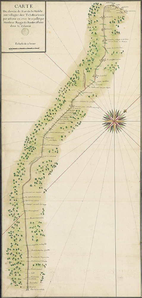
Shown in Figure 2 is another map is another map created in 1732 by Louis Joseph Guillaume de Regis du Rollet, titled Carte du chemin du fort de la Mobile aux villages des Tchaktas levée par estime en 1732 which translates to: Map of the road from Mobile to the Choctaw villages surveyed by estimation in 1732.
Rollet was a French officer who visited the Choctaw homelands and recorded many different Choctaw place names along the Choctaw road from our villages to the French settlement of Mobile. This map is unique because it was created by Rollet himself, who had traveled through these areas taking meticulous notes on the information that his Choctaw guides shared with him. Roullet also had an excellent ear for the Choctaw language and recorded a number of Choctaw place names phonetically in 18th century French (Musco et al. 2025).
The Historic Preservation Department had known about this map for several years, but we were not able to fully translate the Choctaw place names listed on the map because we didn’t know how to pronounce all of the French letters. During our map research, we worked with a French researcher named Jonas Musco. Jonas was studying Rollet’s map and manuscript and during his visit to Oklahoma he met with us to discuss some of his findings. As Jonas, a native French speaker, pronounced the French syllables, the Choctaw names recorded by Roullet became perfectly clear. When he spoke the names, it sounded as if he was Speaking the Choctaw language!
Additionally, Roullet recorded in his journal the description of each Choctaw place name that was told to him by his Choctaw guides. Choctaw place names are often descriptive and highlight landscape features (Musco et al. 2025). Some of the names record tidbits of information about how our ancestors interacted with the land in that spot. Below are a few examples of some of Roullet’s place names. Please note that these translations have not been fully vetted by the Choctaw Nation’s language department.
French recording: Bouk tiak acé tchaba. Roullet’s notes: Bayou where the pine tree serves as a beam. Choctaw Name: Bok tiak hahchvba or Bok tiak alhchvba. English literal translation of Choctaw name: Stream of the pine footbridge or Stream bridged by a pine tree.
French recording: Quinta ouba yllié. Roullet’s Notes: the place resembles a beaver foot. Choctaw: Kinta holba iyyi. English literal translation of Choctaw name: “Like a beaver’s foot” aka muskrat foot.
French recording: Conchakoué chkché. Roullet’s notes: End of the large switch cane. Choctaw: Kushak wishakchi. English literal translation of Choctaw name: Tip or outmost end of the switchcane brake.
French recording: Bouk janache founi atcha. Roullet’s notes: Bayou of the buffalo bones. Choctaw: Bok yvnnvsh foni asha. English literal translation of Choctaw name: Stream where the buffalo bones are.
Of the 73 Choctaw place names that were recorded by Rollet, there were only 7 that our Department could not translate in-full. Through other sources that we have access to, the Historic Preservation Department found that at least nine of the Choctaw place names recorded by Roulette were still being used by Choctaw people well over a century later. Our research is still on going, but our Department has plans to keep working on this project and provide an update in a future Iti Fabvssa article.
References
- Musco, Jonas, Paz Núñez-Regueiro, Everett Bandy, Ryan Spring et Ian Thompson 2025 Back to the Sources. A Collaborative Research Project on the Indigenous Mississippi Valley and Southeast Based on 18th-Century French Maps (Musée du quai Branly-Jacques Chirac and the Choctaw, Miami, Peoria and Quapaw Nations). IdeAs. Idées d’Amériques 26. accessed February 6, 2026.