More Choctaw Place Names in “Oklahumma”
Iti FabvssaPublished November 1, 2023In September 2010, Iti Fabvssa published an article titled Choctaw Place Names in “Oklahumma” in response to a reader who asked:
“Dear Iti Fabvssa,
I’ve got a question about Choctaw towns and places in southeastern Oklahoma and what their names might translate to in English. If possible I’d also like to know a little bit about their history. Thank you.”
-Ryan
Place names in the Choctaw language are extremely important. They indicate not just a Choctaw presence on the land but often also the way that Choctaw people of the past understood the land and interacted with it. Many of the older Choctaw place names talk about resources that were once acquired at that spot, foods or materials for making things. Other Choctaw names record events that happened at certain locations. Still, other Choctaw place names, generally more modern ones, tie the names of families or individuals to certain geographic features.
The Nation’s Historic Preservation Department records every Choctaw place name that we can find here on the Choctaw Reservation and anywhere else that Choctaw place names exist. This helps us to learn more about Choctaw history on the land and to better identify and protect important historic areas. This is a work in progress.
This month, we are excited to share some more Choctaw place names from each of our Districts! If you know of other Choctaw place names and are willing to share, please let us know.
State of Oklahoma
The first Choctaw place name we want to mention is the Choctaw word for Oklahoma. In our previous article, we explained the history and meaning behind the name. In the Choctaw language, Okla is the word for people, and Humma/Homma is the word for red. However, we would like to offer a deeper perspective on the meaning of the name. Traditionally, Homma was a kind of war title given to Choctaw people who didn’t retreat (Byington, 1915, p. 170). In this context, Oklahoma translates to people who do not retreat.
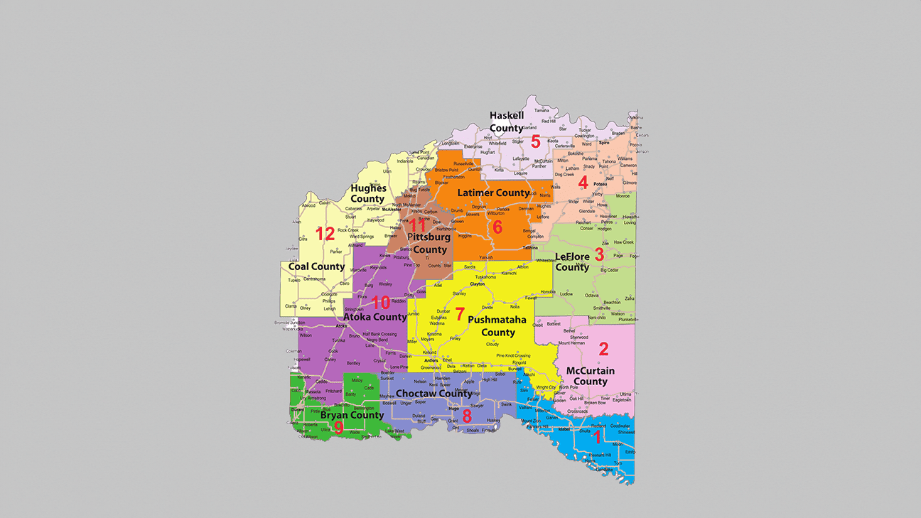
District 1
Near Millerton used to be a small Choctaw community named Chula, meaning fox (Shirk 1987: 51). Southwest of Idabel is a place known as Shawneetown. Before the Choctaw Trail of Tears in the 1830s, a village of Absentee Shawnee were living there. Learning of the Choctaw removal to the area, the Absentee Shawnee moved. Choctaws called the area Kvlih Chukchu, Maple Springs, and later, its name changed to Kvlih Inla or New Springs (Shirk, 1987, p. 135). South of Idabel is Mintubbe Lake, a natural lake formed when the course of the Red River shifted. Its name comes from Okhvta Minti Vbi or Comes and Kills Lake (Gannet, 1905, p. 46). Mintubi is the personal name of a Choctaw warrior. The Little River is an important river in McCurtain County and acts as the border between District 1 and District 2. Its name in Choctaw is Bok Iskitini or Little River (Hudson, 1932, p. 514).
District 2
Another important river in McCurtain County is the Glover River, which Choctaws have called Chalakki Bok, meaning Cherokee River (Hudson, 1932, p. 514). It is believed that before statehood, a group of Cherokee people settled on the Glover River. It is possible this was a group of Cherokee refugees that moved into the area during the American Civil War due to the devastation the war had on Indian Territory.
West of Broken Bow is Yashau Creek. Yashu was the name of two different Choctaw villages in Mississippi before removal, named West Yashu and East Yashu. We were once told by a local elder and first language speaker that the name Yashu itself comes from a Choctaw word for cooking pot, but we haven’t heard that from anyone else. Southeast of Broken Bow was an old town that is no longer in existence named Okolona, or Oka Lobali meaning a place caved in or washed out by water (Shirk, 1987, p. 177). To the Northwest of Broken Bow is another town that is no longer in existence that was called Opa or Owl.
Ossi Tamaha is the Choctaw name for Eagletown, and it name means the same in Choctaw. Just south of Eagletown is Buck Creek, called Lapitta Bok or Stag Creek (Hudson, 1932, p. 502). East of Eagletown is the town of Ultima Thule, called Yakni Vlhpisa or measured land (ibid.). Nearby is the stream of Rock Creek called Tvli Bok, or Rock River (Hudson, 1932, p. 501). West of Eagletown is Luksuklo Creek, which translates to Luksi Okla or Turtle People (Hudson, 1932, p. 506). West of Luksuklo Creek is Lick Creek, which was called Peter I Bokushi or Little Creek That Belongs to Peter [Pitchlynn] (Hudson, 1932, p. 506). Southeast of Eagletown is the Mountain Fork Presbyterian Church, which was established in 1837; it is known as Nvnih Lumbo or Round Hill.
Hochatown was known as Hocha Tamaha. Hocha was the name of 1 of 12 families that lived in the area after the Trail of Tears. Daniel Hocha was raised in Hochatown but changed his name to Daniel Bobb and moved to Smithville. Daniel’s son, Johnson Bobb, attended the Folsom Academy in Smithville and became a Methodist Minister and fought in World War I. Johnson’s son, Bertram Bobb, was the Chaplain of the Choctaw Nation and established the Bertram Bobb Bible Camp at Ringold, Oklahoma (Facebook: Kenny Sivard, McCurtain County Historical Society, Home of Daniel Bobb, February 27, 2018).
District 3
Heading north to District 3, we encounter the town of Smithville, known as Hattak Vbi or Man Killer in Choctaw (Smithville, The Encyclopedia of Oklahoma History and Culture). Running by the southside of Smithville is the Mountain Fork River, known as the Nvnih Hvtcha or hill river in Choctaw (Hudson, 1932). To the west of Smithville is Honobia Creek, named Nochonohonubbe Creek. At this time, we do not have a translation. (Honobia Creek, GNIS). South of Smithville is the community of Nvnih Chito or Big Hill (Nani-chito, GNIS). In the northern part of District 3 are Hontubby, Hontubby Creek, and Hontubby Falls, which all come from the Choctaw words Hoyot Ant Vbi or to wait and kill (Heavener Historical Society, 2013).
District 4
On the southeastern side of District 4 is Sugarloaf Mountain, known as Nvnih Chufvk or Fork Mountain in Choctaw (Mihesuah, 2010). Northeast of Sugarloaf Mountain is the town of Cameron, known as Kvlih Chaha or High Springs (Shirk, 1987, p. 135). Northeast of Cameron is Tahona or Hoyo Ona, which means goes and seeks (Read 1934: 347). Near Poteau is Cavanal Hill, which is French for cavern. Similarly, Choctaws named it Hochukbi, meaning cave or cavern (Shirk, 1987, p. 117).
District 5
District 5 is bordered on the north by the Arkansas River, which Choctaw people used as a water road to trade with the Quapaw Tribe. We call the Arkansas River the Okhapa Oka Hina or Quapaw water road (Byington, 1915, p. 387). The Choctaw word Okhapa comes from the Quapaw word OGahPah, which is the name they have for their people. North of Stigler is Taloka Creek, which comes from Itola Oka or a place where water remains, such as a dam or a shoal where water has collected (Shirk, 1983, p. 237). Emachaya Creek could be Bok Imachaya or accustomed place creek (Gannet 1905: 32). Southeast of Longtown is Haytubbi Creek. Haytubbi is a Choctaw warrior’s name, made from contracted words.
Districts 6 and 7
In District 6, north of Wilburton, is a creek called Cunneo Tubby Creek which comes from the Choctaw phrase Kvnia Vbi or goes away and kills, the name of a warrior (Cunneo Tubby Creek, GNIS). Similarly, in District 7 is the town of Antlers, which also held the Choctaw name Kuniotubbee or Kvnia Vbi or goes away and kills, the name of a warrior (Pushmataha County, The Encyclopedia of Oklahoma History and Culture). Near the town of Nashoba is the Black Fork River, called Bok Lusa or black river (Hudson, 1932, p. 514). Choctaw speakers often hear familiar sounds in the name “Kiamichi River,” but this name appeared on maps before Choctaw people moved into the area. The name Kiamichi comes from the Caddo language Kia May Che, meaning the water running into the stream running into the big river (Carter, 1995, p. 267).
Districts 8 and 9
In District 8, south of Hugo, is Goodland Academy Boarding School. “Goodland” comes from the Choctaw words Yakni Achukma (goodland.org). To the west of Goodland Academy is Hanubby Creek, or Hvnvn Vbi or Hawk Killer (Toomey, 1917, p. 9). To the north of Fort Towson used to be the Chuwahla Female Seminary. Chuwahla means cedar tree. The southern border of District 8 is the Red River, also known as Bok Homma, which has the same meaning in Choctaw. In District 9, south of Bennington is the Chishoktak Church or Chisha Oktak. Its name means post oak prairie (Sue Folsom, personal communication). In the past, as you would come into Durant from the north, you would pass over Chuckwa Creek. Chuckwa may come from the Choctaw word Chukoa or to enter. Crossing Chukwa Creek would mean you had entered the town limits of Durant (Evangeline Robinson, personal communication).
District 10
Before the Civil War, Atoka County was called Shappaway County, a name which comes from the Choctaw words Shvpha Weli, meaning to hold out a flag (Atoka County, The Encyclopedia of Oklahoma History and Culture). Between the towns of Caney and Cook is the town Taloah, a name that comes from Taloa or to sing. North of Atoka is the town of Stringtown called Kvlih Tamaha in Choctaw or Spring Town (Magby, 2020, p. 52). East of Stringtown is Potapo Creek, which may have been named after a Choctaw individual who lived along the creek (Shirk, 1987, p. 196). On the eastern side of District 10 is Daisy. Daisy used to be called Kvlih Laua or Many Springs. Kvlih Laua was the capital of the Choctaw Nation’s Jacks Fork County and held the Choctaw County courthouse.
Districts 11 and 12
In District 11, south of Bache, is the Nvnih Chaha Cemetery or high hill. In the northwestern part of District 12 is Allen, which Choctaw people called Oka Kapvssa or cold springs (Allen, The Encyclopedia of Oklahoma History and Culture). Just to the east of Allen is Arbeca Creek, which gets its name from Bok Abeka Aiasha or sickly or unhealthful dwelling place (Gannett, 1905, p. 12). On the far south side of District 12 is the town of Olney, which is said to get its name from the Choctaw name Pvla Misha or lighted place in the distance (Shirk, 1987, p. 186).
The Choctaw Nation Historic Preservation Department has been identifying and recording Choctaw Place Names since 2012 in our Choctaw Place Names Database. This digital mapping database is used by our Department to protect our Choctaw historic and sacred sites, repatriate our ancestors, and aid in educating Choctaw youth. We are always actively looking to learn more about Choctaw place names. If you would like to share a Choctaw place name with our Department, please visit our Historic Preservation Resources page. You can learn more about our historic preservation efforts.