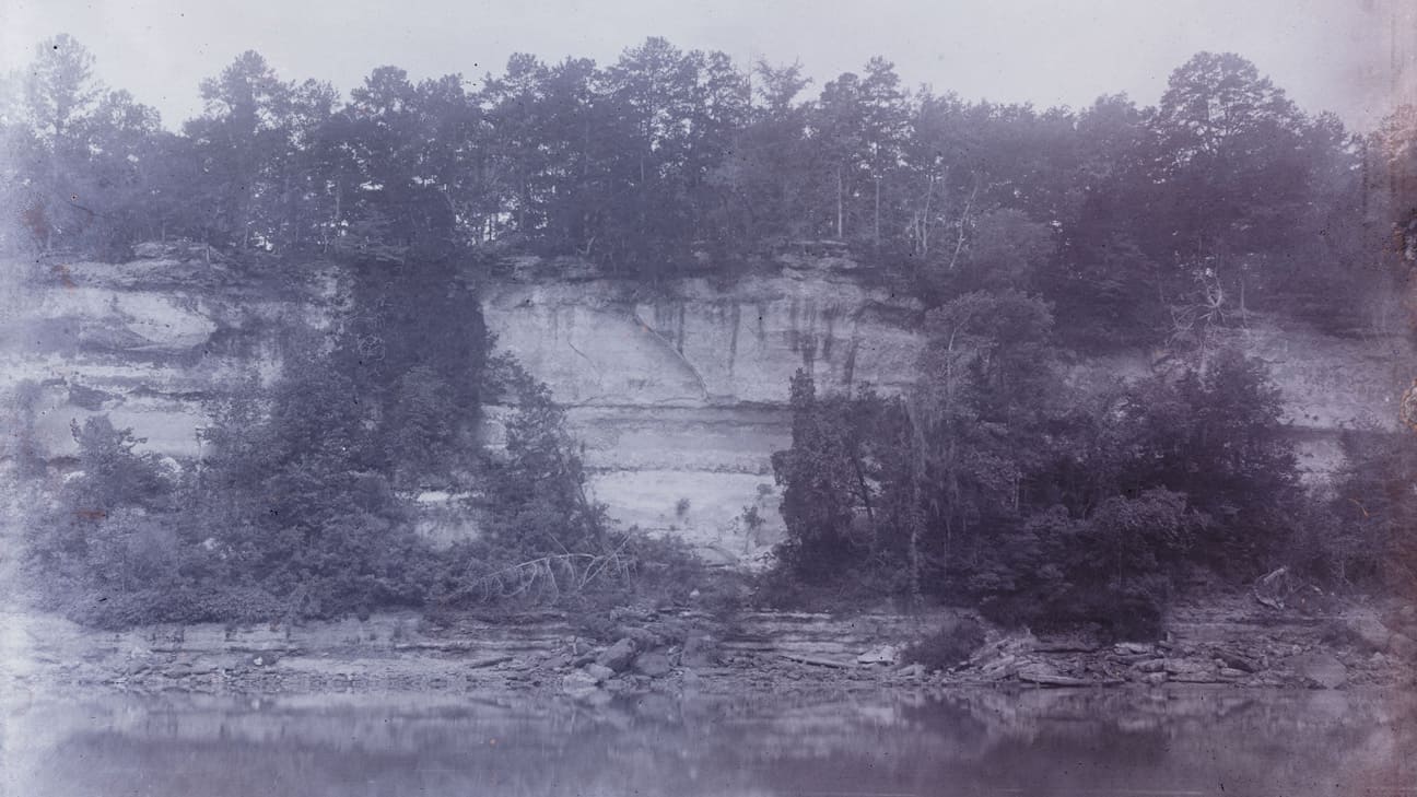
 Photo Credit St. Stephens Bluff/The University of Alabama Libraries Special Collection
A river bluff at Hobvk Itopa in 1885.
Choctaw Town of Hobvk Itopa
December 1, 2023
In west-central Alabama is the small town called Bladen Springs. This quiet town in Choctaw County, Alabama, is located in what used to be a very important crossroads in the Choctaw Nation. Before the Trail of Tears, a community of Choctaw people lived in a group of settlements near here named Hobvk Itopa. Located on two important Choctaw trade paths, this community was a large trading hub. Over time, it was located on the frontier between the Choctaw and the Muscogee, French, Spanish, British, and, finally, the United States. This month, Iti Fabvssa would like to share some history about the settlements of Hobvk Itopa.
Choctaw oral histories and archaeological evidence show that Choctaw ancestors have lived in this region of Alabama for thousands of years (Thompson 2008). During the 1600s, many Choctaw communities living on major waterways farther east in Alabama moved west into Mississippi due to European diseases and English-sponsored slaving raids from the east (Thompson 2019:27-28). Both of these traveled on rivers. Moving closer to the ancestral Choctaw home of Nvnih Waiya offered better protection from attacks and an opportunity to rebuild and reorganize our communities (White 1983). Choctaw communities already living in east-central Mississippi, what we consider today to be the heart of the Choctaw homelands, merged with the Choctaw communities coming from west-central Alabama and southwestern Alabama.
Because so many different Choctaw communities were coming together, we adopted societal changes that helped merge our people together. These societal changes and the adoption of additional Choctaw-speaking communities from the east helped bring about three Choctaw Nation districts. Later, in the 1760s, after wars with the Chickasaw and Muscogee ended, Choctaw settlements began expanding back into west-central Alabama.

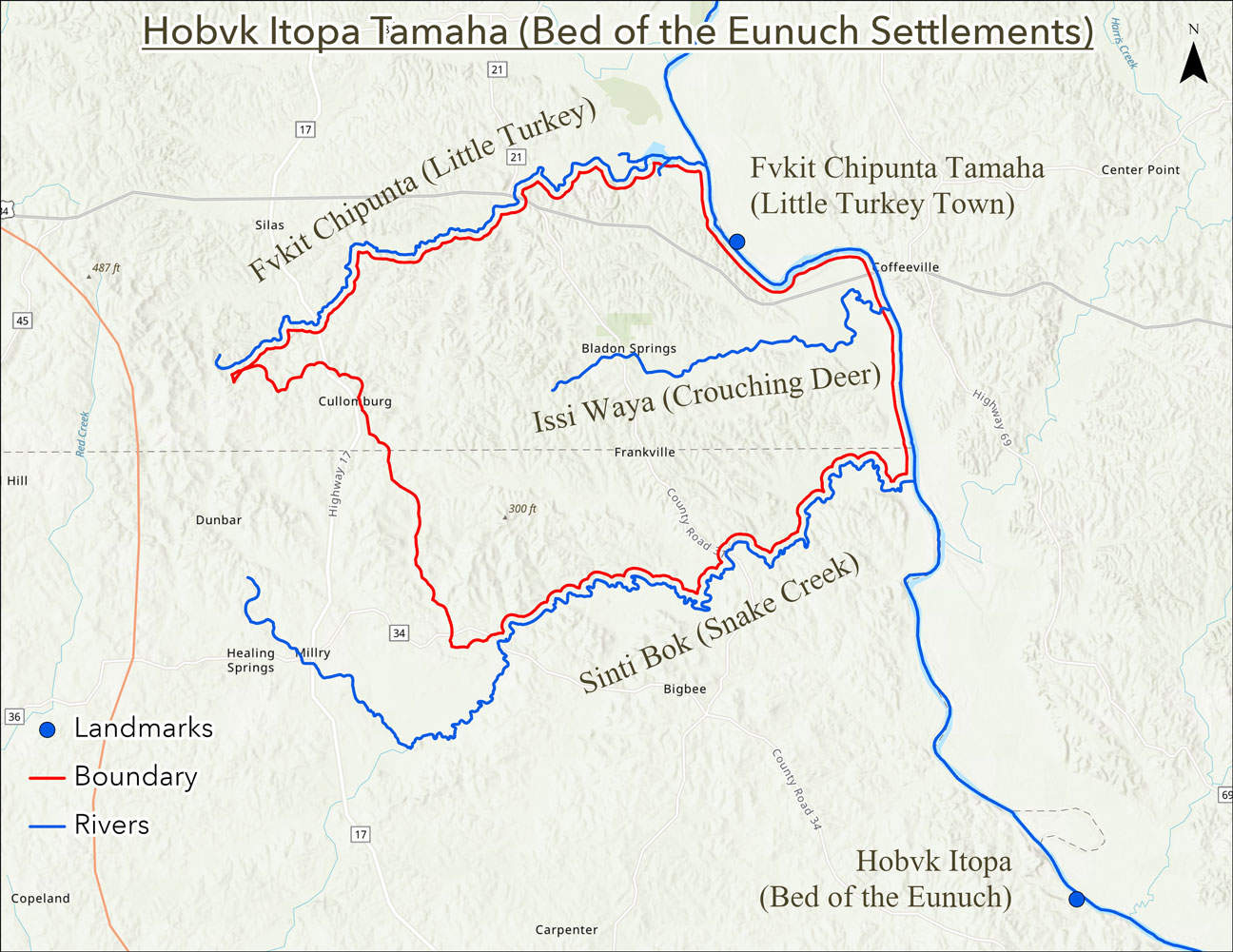
Map of the boundaries and place names of Hobvk Itopa near Bladen Springs, Alabama.
Sometime after 1760, a community of Choctaw people moved east and settled in the area of Hobvk Itopa. The town took its name from a local bluff to the south known by Choctaw people as Hobvk Itopa. Hobvk Itopa translates to Bed of the Eunuch; Henry S. Halbert describes the story of how Hobvk Itopa received its name in his publication “Choctaw Indian Names in Alabama and Mississippi.” Publications of The Alabama Historical Society. Transactions, Volume III. Ed. Thomas McAdory Owen. Tuscaloosa: The Alabama Historical Society, 1899. 68. Today, this bluff is known as Cowan’s Bluff (see Figure 1) and is located near St. Stephens, Alabama. The town of Hobvk Itopa was spread out across a large area. The village spanned the area between Turkey Creek and Santa Bogue Creek, a north-south distance of about 10 miles (Halbert 1915 Box 4, Folder 13 and 14). It was presumably bounded on the east by the Tombigbee River and on the west by the dividing ridge of the watershed, an east-west distance of about 10 miles.
In the immediate vicinity of Hobvk Itopa, the northern boundary of Turkey Creek was called Fvkit Chipunta or Little Turkey. Its name comes from the nearby Choctaw village of Fvkit Chipunta, located to the northeast of Hobvk Itopa. In the central part of the Hobvk Itopa is Sea Warrior Creek, which draws its name from the Choctaw name Issi Waiya, meaning Crouching Deer. To the east of Hobvk Itopa is the Tombigbee River. It derives its English name from the Choctaw phrase Itombi Ikbi, meaning coffin maker (Byington 1915:216). This name came about as a result of a misunderstanding when Frenchmen asked Choctaw guides the name of the Tombigbee River. The Choctaw name for the Tombigbee River is Hvcha Hattak, meaning river people. The name that the Choctaw people call ourselves is Chahta and may be a contraction of Hvcha Hattak (Halbert 1915 Box 10, Folder 2). To the south of Hobvk Itopa is Santa Bogue Creek. This derives from the Choctaw name for this stream, Sinti Bok, meaning snake creek. There have been fossil remains of Basilosaurus cetoides found on Snake Creek. Early paleontologists believed that Basilosaurus cetoides was a type of extinct reptile. Thus, the original word meant king lizard (Ehret 2017). The Alabama Museum of Natural History in Tuscaloosa, Alabama, has a Basilosaurus cetoides on exhibit.
The most notable trade road in the Southern part of the Choctaw Nation was a trail that led from Natchez, on the west bank of the Mississippi River, east to the southernmost Choctaw village of Haiyowvni or cutworm, continuing east to Hobvk Itopa (Halbert 1915 Box 4, Folder 11). The road then forks, one road traveling south to reach Mobile and the other road going east across the southernmost crossing of the Tombigbee River to the Muscogee Nation (ibid). The last Chief of Hobvk Itopa was Piamingo Himita, or Young Wooping Chief (Halbert 1915 Box 4, Folder 13 & 14).
We are currently unaware of surviving detailed descriptions of daily life at Hobvk Itopa, but it would have been similar to what has been described for other surrounding Choctaw settlements from the same time period. The new year began around the fall equinox. Elder men began building and refurbishing the community’s winter homes. Younger, more able-bodied men and women left the main settlement and traveled to hunting camps on the Tombigbee or its tributaries, including the eastern bank. Famed Choctaw Chief Pushmataha first entered living memory in one of these Tombigbee River hunting camps. In these camps, families lived in bark-covered A-frame structures (Halbert 1915 Box 4, Folder 4). Hunters focused on deer in the early part of the season. In the coolest part of winter, they moved to dense cane brakes and hunted bears and smaller fur-bearing animals. Some families would have left the hunt early to spend the season trading on the outskirts of the town of Mobile. As spring approached, Hobvk Itopa’s dispersed residents returned to their settlements and began to prepare agricultural fields. House fields, the first to be planted, were located immediately adjacent to families’ residences. The main communal agricultural fields were planted on elevated, silty loam soil near drainages in early May. These fields consisted primarily of corn, beans, and winter squash. The last fields to be planted were melon patches, sometimes located at quite a distance from a family’s house. Women sat on elevated, shaded platforms, keeping watch over their fields during the growing season. Crops were laid by during the hottest part of the summer, while families went to local streams to cool off and harvest aquatic resources. They returned to their summer residences for harvest.
Most Choctaw settlements from this time period had a central dance ground. Nearby were community leaders’ homes and the community’s communal food stores, kept in corn cribs. Female relatives set up their homes so that they were neighbors, with about 200 yards, the distance of a bow shot of space between them. As noted above, Hobvk Itopa’s settlements were spread out for miles in each direction. This allowed them to have relatively easy access to cropland. In the 1700s, most Choctaw towns buried their deceased in small, conical earth mounds located on ridges, away from the settlement itself.
In 1789, Spain built Fort San Esteban at the bluff of Hobvk Itopa, which would later become Fort. St. Stephens. Spanish people from Mobile began applying for land grants in the Hobvk Itopa area. In the past, the town of Hobvk Itopa may have extended even farther south, given that Indian Land Grants issued in 1778 and 1799 south of Santa Bogue Creek refer to the settlements of Hobvk Itopa (Owens 1921). In 1803, the Treaty of Hoe Buckintoopa was signed between the United States and the Choctaw Nation at Fort St. Stephens. Like the bluff and settlements, the treaty derives its name from the Choctaw name Hobvk Itopa. In 1805, the Choctaw Nation was forced to cede additional lands in the Treaty of Mount Dexter, which included the settlements of Hobvk Itopa. Some Choctaw families stayed in the area after this date (Matte 2002:28). However, we are currently unable to give an exact end date for the settlement’s Choctaw occupation. It is possible that families stayed in the area until the beginning of the Red Stick War in 1813.
The town of Hobvk Itopa existed during a time of change and adaptation for the Choctaw people. Peace with our neighbors allowed us to move back into our lands in Alabama while continued trade with the Muskogee, French, Spain, Britain and the United States empowered this settlement to be an important trade hub and travel center for all people that passed through the area. Both the families of Pierre Juzan and Benjamin James are known to have lived in the area of Hobvk Itopa before the Trail of Tears. (Martini 1986). Maybe one of your ancestors lived in the town of Hobvk Itopa?
About Iti Fabvssa
Iti Fabvssa seeks to increase knowledge about the past, strengthen the Choctaw people and develop a more informed and culturally grounded understanding of where the Choctaw people are headed in the future.
Additional reading resources are available on the Choctaw Nation Cultural Service website. Follow along with this Iti Fabvssa series in print and online.
Inquiries
If you have questions or would like more information on the sources, please contact Ryan Spring at [email protected].

